SPATIAL DATA - 3D RECONSTRUCTION OF THE MONASTERY OF ST. MODESTOS
Information System for Multi-Level Documentation of Religious Sites & Historic Complexes, Acronym: 5dMeteora
3D Reconstruction Methodology of the buildings of the Monastery:
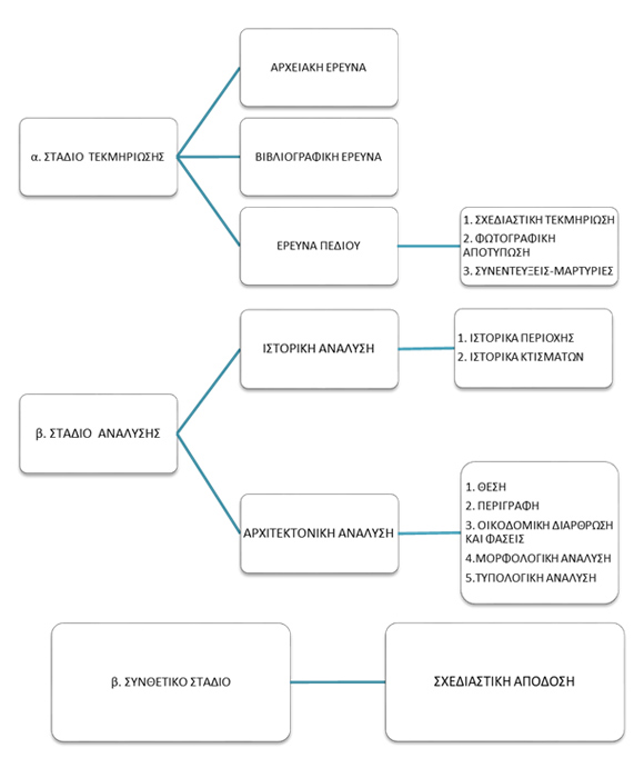
In the context of the project, the 3D reconstruction of the buildings of the non-existent monastery of St. Modestos will be created based on the systematic archeological, historical and architectural study. The 3D model will be available both on the platform and as an overlay on the real environment through the AR mobile application. The architectural modelling procedure for historical – archaeological sites and monuments consists of three phases: the documentation, the analysis and the synthesis (Figure 1).
The implementation of an architectural reconstruction process requires a set or more of several documentary sources. Such types of information investigate the existence of the case study and provide a degree of accuracy regarding its dimensional and geometric consistency, so that the representation is more reliable and accurate. The 3D reconstruction of the monastery is based on the following data:
- Bibliographic and historical evidence that document the presence of an important building complex on the surface of the rock: Chalcographies (engravings on copper plates) and references to manuscripts of past centuries validate its existence. Even if the archival material may not be considered sufficient or accurate enough in providing dimensional, formal and construction information of the buildings, it is a primarily step for assumptions and hypothetical plans.
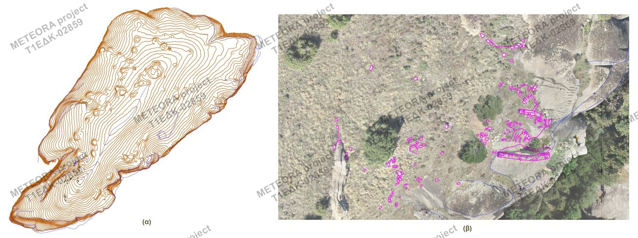
- Elevation data for the rock of Modi: Specifically, contour lines at 1-meter intervals for the rock of Modi and at 0.1-meter intervals for specific areas of its surface where ruins of old structures were found, derived from the dense point cloud.
- Digitation of characteristic structural elements and ruins on the rock of Modi: In particular, all the findings, such as remains of the destroyed monastery, building stones and other constructive elements were stereoscopically detected and rendered in 2D drawings using a Digital Photogrammetric Station. Figure 2 shows the digitized elements (with a purple line) on top of the orthoimage-floor plan of the rock of Modi. These observations infer that there was a building complex, not of negligible size (Figure 2a and 2b).
- Orthoimage – floor plan (orthographic projection to a horizontal plane) of rock of Modi as well as orthoimages of the western side of the rock, of the faces of the tower and of the carved stone steps, as cross sections (orthographic projections to vertical planes).
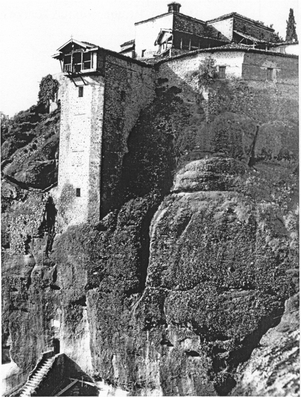
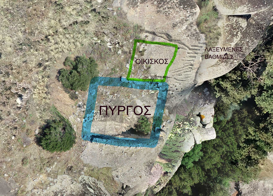
With these documentary sources, the monastery was interpreted in the light of the architectural design of buildings of the monastic complex of Meteora site with common style and/or the same historical period. The architectural activity is governed by specific characteristics, determined by the geomorphology, the time, the geopolitical events, the materials and the needs of the monastic community in the given period. In particular, the photo-interpretation and the comparative study with structures of the same period along with formal data, materials and construction methods lead to (i) the identification of a tower with foundations on the lowest part of the rock, according to the spatial position of stratification of towers that exist in the monasteries of Holy Trinity, of the Transfiguration (Metamorphosis) - Great-Meteoron (Figure 3), (ii) the validation of the existence of a stone platform at a lower altitude, with a hut and steps carved into the rock (Figure 4), as well as (iii) the validation of the existence of monastic cells indicated by both the building stones on the left of the tower and the preserved rock-cut water tanks (cisterns) that met the needs of the monastic community
3D reconstruction software:
The software used for the 3D reconstruction of the buildings of the monastery of St. Modestos is Archicad version 23. Initially, the geospatial data of the relief are imported, in order to generate a precise geomorphological model of the terrain where the 3D reconstruction will lie. Then, the 3D model of the buildings and the other constructive elements (i.e. climbing stairs) are created based on the conclusive results and documentation data described above. Next step is the creation of the raster materials from real images, which will give a realistic texture to the 3D surface. The final 3D models will be exported in a compatible with the AR mobile application format.